2D:Dialog ClimateFileSelectMap: Unterschied zwischen den Versionen
Len (Diskussion | Beiträge) Die Seite wurde neu angelegt: = Dialog: Climate File | Select from Map = = Dialog: Climate File | Select File = Bild:DialogSelectClimateFileFromMap_04.gif <P> Those locations for which climat... |
(kein Unterschied)
|
Aktuelle Version vom 3. Juli 2008, 09:02 Uhr
Dialog: Climate File | Select from Map
Dialog: Climate File | Select File
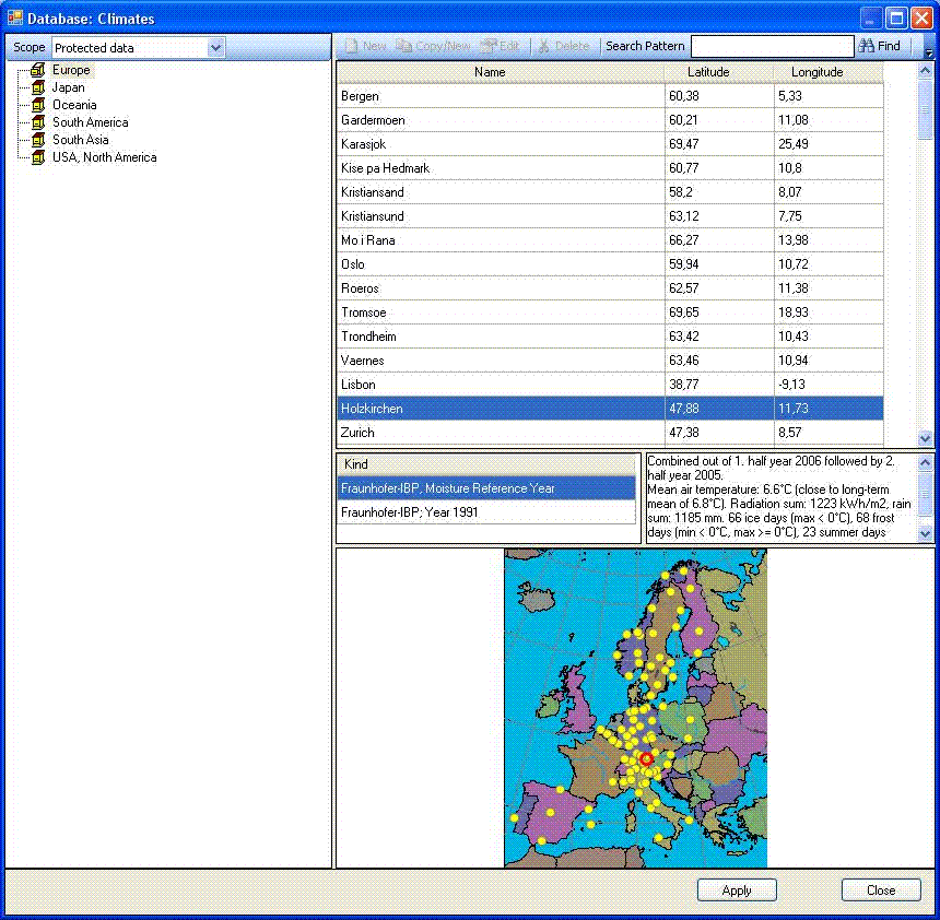
Those locations for which climate files are supplied with WUFI
and some predefined locations for which climate files are available
from other sources can be
selected from this dialog's maps with a simple mouse click.
To select climate files created by yourself or
acquired otherwise, please
use the option
"Select user-defined
file".
You may zoom into the maps by dragging open a zoom frame from upper left to lower right at the desired location. You may pan a zoomed map with the right mouse button held down. You may zoom out by dragging open a zoom frame from lower right to upper left.
"Region/Continent":
Select the desired map. Currently Europe, North America
and Japan are available.
"Location":
This drop-down list contains all the locations on the map in
alphabetic sequence and offers an alternative way of selecting
a location.
"Climate file",
If several files are available for a location (e.g. one warm
and one cold year), you must select here the desired file.
"Remarks":
If comments or remarks are available for the selected file,
they can be displayed here.
Currently, the following climate files are supplied with WUFI:
- Holzkirchen (1991),
- Kassel,
- Vienna, Graz, Innsbruck
- Zürich, Davos, Locarno (one 'warm' and one 'cold' year each),
- Warsaw, Krakow, Kolbrzeg
- Grenoble
- Lissabon
- Espoo (in the Finnish Pro version also Helsinki, Jyväskylä und Sodankylä)
- 12 Norwegian cities
- 55 US-American cities (the 10%-coldest and the 10%-warmest year selected from 30 years),
- 9 Canadian cities (some of them with one warm and one cold year)
- 7 Japanese cities.
The Holzkirchen weather data are supplied by IBP, other data are courtesy of Mr. William Seaton, ASHRAE (USA and Canada), Dr. K. Krec, Büro für Bauphysik (Austria), Dr. Ghazi Wakili, EMPA (Switzerland), Dr. W. Haupt, Uni GH Kassel (Kassel), CSTB (Grenoble), FEUP, Uni Porto (Lisbon), VTT (Finland), NBI/NTNU (Norway), TU Lodz (Poland) and the Architectural Institute of Japan (AMeDAS data for Japan).
The colors of the available locations indicate the file format
of the respective weather files. Predefined locations for which
weather data can be purchased separately are grey. Please copy
such a file into WUFI's Climate folder; on the next start
WUFI will recognize the file and display the location in color.
WUFI is prepared to read the Test Reference Years from the German
Weather Service DWD, both the 'old' (Blümel et al., 1986,
*.TRY; not offered
any more by DWD) and the 'new' files (Christoffer et al., 2004,
*.DAT).
There are also 842 predefined locations for Japan (depending on
the WUFI version, data for one or seven locations are included
with WUFI).
See the topic Sources for
Climate Data for where to purchase such files.
The Holzkirchen climate file currently supplied with WUFI contains the measured data from 1991 which is considered typical for Holzkirchen. Future WUFI versions may come with two Hygrothermal Reference Years representing different stress situations for building components.
Dialog: Climate File | Select File
This dialog serves to select a user-defined climate file for the
calculation. The files supplied with WUFI can be selected from
maps.
"Browse...":
This button opens a file dialog in which you can select the desired file.
"Additional Geographic Data":
To be able to convert the solar radiation data contained in the
climate files for receiving surfaces at arbitrary orientation and
inclination, WUFI needs to compute the position of the sun in the
sky, and for this it must know the geographic coordinates and the
time zone of the climate location.
Since most climate file formats do not contain these data, they must
be provided by some other means. For the files supplied with WUFI
they have been filed in the database. For each user-defined climate
file the user must create an
*.AGD file with the relevant supplementary
data.
Note: We recommend to always specify the climate file with its full path. Otherwise ambiguities might arise, especially if the climate file is accompanied by an
*.AGD file.

